Thank you for supporting this site ❤️
Make a donation
Make a donation
Gear up for your next adventure:
As an Amazon Associate, this site earns from qualifying purchases at no extra cost to you.
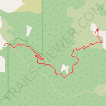
Rangiwahia Hutt walk
- Distance: 5.8 mi
- Elevation gain: 743 m
- Maximum elevation: 1,311 m
- Elevation loss: 740 m
- Minimum elevation: 821 m
- Moving time: 2 h 40 m
- Moving speed: 2.2 mph
- Maximum speed: 12.4 mph
- Total time: 3 h 17 m
- Global speed: 1.8 mph
Interactive trail map
Thank you for supporting this site ❤️
Make a donation
Make a donation
Gear up for your next adventure:
As an Amazon Associate, this site earns from qualifying purchases at no extra cost to you.
Trail profile
- Distance: 5.8 mi
- Elevation gain: 743 m
- Maximum elevation: 1,311 m
- Elevation loss: 740 m
- Minimum elevation: 821 m
- Moving time: 2 h 40 m
- Moving speed: 2.2 mph
- Maximum speed: 12.4 mph
- Total time: 3 h 17 m
- Global speed: 1.8 mph
Thank you for supporting this site ❤️
Make a donation
Make a donation
Gear up for your next adventure:
As an Amazon Associate, this site earns from qualifying purchases at no extra cost to you.
About this trail
Name: Rangiwahia Hutt walk trail, distance, elevation, map, profile, GPS track
Start: Renfrew Road, Manawatū District, Manawatū-Whanganui, New Zealand (-39.89371 175.99661)
End: Renfrew Road, Manawatū District, Manawatū-Whanganui, New Zealand (-39.89379 175.99669)
Coordinates: -39.89951 175.99661 -39.89059 176.01942
Thank you for supporting this site ❤️
Make a donation
Make a donation
Gear up for your next adventure:
As an Amazon Associate, this site earns from qualifying purchases at no extra cost to you.