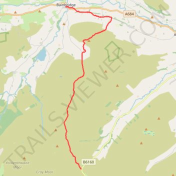
Hike from Kirkstone Pass to Bainbridge via Addlebrough
- Distance: 9.0 mi
- Elevation gain: 268 m
- Maximum elevation: 561 m
- Elevation loss: 467 m
- Minimum elevation: 218 m
- Moving time: 3 h 41 m
- Moving speed: 2.4 mph
- Maximum speed: 4.3 mph
- Total time: 4 h 14 m
- Global speed: 2.1 mph
Interactive trail map
Trail profile
- Distance: 9.0 mi
- Elevation gain: 268 m
- Maximum elevation: 561 m
- Elevation loss: 467 m
- Minimum elevation: 218 m
- Moving time: 3 h 41 m
- Moving speed: 2.4 mph
- Maximum speed: 4.3 mph
- Total time: 4 h 14 m
- Global speed: 2.1 mph
About this trail
Name: Hike from Kirkstone Pass to Bainbridge via Addlebrough trail, distance, elevation, map, profile, GPS track
Coordinates: 54.21927 -2.10469 54.30658 -2.06097
Topography: North Yorkshire topographic map, elevation, terrain
Other hiking, mountain biking, running and outdoor activity trails
Click on a trail to view its statistics, map and profile.
Hike up Yockenthwaite Moor
United Kingdom > England > North Yorkshire > Buckden
Distance: 8.2 mi • Elevation gain: 250 m • Maximum elevation: 643 m