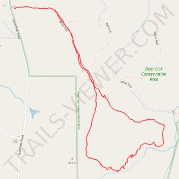
Deer Lick Conservation Area Orange Trail Loop
- Distance: 2.0 mi
- Elevation gain: 59 m
- Maximum elevation: 413 m
- Elevation loss: 57 m
- Minimum elevation: 376 m
- Moving time: 1 h 13 m
- Moving speed: 1.7 mph
- Maximum speed: 3.1 mph
- Total time: 1 h 27 m
- Global speed: 1.4 mph
Interactive trail map
Trail profile
- Distance: 2.0 mi
- Elevation gain: 59 m
- Maximum elevation: 413 m
- Elevation loss: 57 m
- Minimum elevation: 376 m
- Moving time: 1 h 13 m
- Moving speed: 1.7 mph
- Maximum speed: 3.1 mph
- Total time: 1 h 27 m
- Global speed: 1.4 mph
About this trail
Name: Deer Lick Conservation Area Orange Trail Loop trail, distance, elevation, map, profile, GPS track
Start: White Trail, Town of Persia, Cattaraugus County, New York, United States (42.41993 -78.90515)
End: White Trail, Town of Persia, Cattaraugus County, New York, 14070, United States (42.41977 -78.90225)
Coordinates: 42.41091 -78.90521 42.41999 -78.89405