Thank you for supporting this site ❤️
Make a donation
Make a donation
Gear up for your next adventure:
As an Amazon Associate, this site earns from qualifying purchases at no extra cost to you.
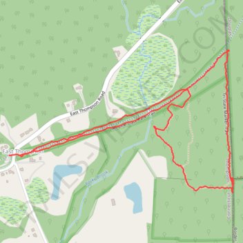
Air Line State Park Trail and Tri-State Marker Loop Trail
- Distance: 1.9 mi
- Elevation gain: 62 m
- Maximum elevation: 185 m
- Elevation loss: 62 m
- Minimum elevation: 143 m
- Moving time: 1 h 4 m
- Moving speed: 1.8 mph
- Maximum speed: 3.8 mph
- Total time: 1 h 17 m
- Global speed: 1.5 mph
Interactive trail map
Thank you for supporting this site ❤️
Make a donation
Make a donation
Gear up for your next adventure:
As an Amazon Associate, this site earns from qualifying purchases at no extra cost to you.
Trail profile
- Distance: 1.9 mi
- Elevation gain: 62 m
- Maximum elevation: 185 m
- Elevation loss: 62 m
- Minimum elevation: 143 m
- Moving time: 1 h 4 m
- Moving speed: 1.8 mph
- Maximum speed: 3.8 mph
- Total time: 1 h 17 m
- Global speed: 1.5 mph
Thank you for supporting this site ❤️
Make a donation
Make a donation
Gear up for your next adventure:
As an Amazon Associate, this site earns from qualifying purchases at no extra cost to you.
About this trail
Name: Air Line State Park Trail and Tri-State Marker Loop Trail trail, distance, elevation, map, profile, GPS track
Coordinates: 42.00758 -71.80929 42.01236 -71.79915
Thank you for supporting this site ❤️
Make a donation
Make a donation
Gear up for your next adventure:
As an Amazon Associate, this site earns from qualifying purchases at no extra cost to you.