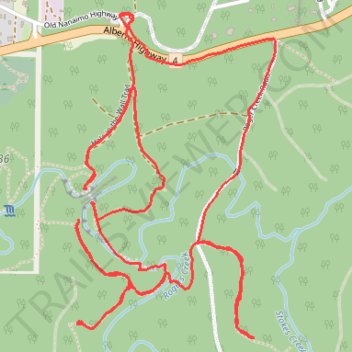
Hall-in-the-Wall Loop Trail
- Distance: 4.1 mi
- Elevation gain: 230 m
- Maximum elevation: 193 m
- Elevation loss: 235 m
- Minimum elevation: 113 m
- Moving time: 2 h 17 m
- Moving speed: 1.8 mph
- Maximum speed: 17.6 mph
- Total time: 3 h 39 m
- Global speed: 1.1 mph
Interactive trail map
Trail profile
- Distance: 4.1 mi
- Elevation gain: 230 m
- Maximum elevation: 193 m
- Elevation loss: 235 m
- Minimum elevation: 113 m
- Moving time: 2 h 17 m
- Moving speed: 1.8 mph
- Maximum speed: 17.6 mph
- Total time: 3 h 39 m
- Global speed: 1.1 mph
About this trail
Name: Hall-in-the-Wall Loop Trail trail, distance, elevation, map, profile, GPS track
Coordinates: 49.25635 -124.74880 49.26626 -124.73948
Other hiking, mountain biking, running and outdoor activity trails
Click on a trail to view its statistics, map and profile.
Sproat Lake - Nanaimo
Canada > British Columbia > Alberni-Clayoquot Regional District > Area D (Sproat Lake)
Distance: 54.0 mi • Elevation gain: 1,273 m • Maximum elevation: 422 m
Port Alberni - Hole in the Wall
Canada > British Columbia > Alberni-Clayoquot Regional District > Area F (Cherry Creek)
Alberni Rogers Creek Woodlands. #Hiking #AlberniRogers
Distance: 0.8 mi • Elevation gain: 50 m • Maximum elevation: 160 m
Parks paths
Canada > British Columbia > Regional District of Nanaimo > Parksville
Distance: 30.3 mi • Elevation gain: 918 m • Maximum elevation: 424 m