Thank you for supporting this site ❤️
Make a donation
Make a donation
Gear up for your next adventure:
As an Amazon Associate, this site earns from qualifying purchases at no extra cost to you.
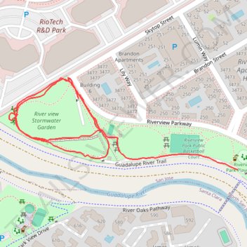
Riverview Stormwater Garden
- Distance: 0.9 mi
- Elevation gain: 2 m
- Maximum elevation: 7 m
- Elevation loss: 2 m
- Minimum elevation: 5 m
- Moving time: 19 m 19 s
- Moving speed: 2.8 mph
- Maximum speed: 4.3 mph
- Total time: 28 m 45 s
- Global speed: 1.9 mph
Interactive trail map
Thank you for supporting this site ❤️
Make a donation
Make a donation
Gear up for your next adventure:
As an Amazon Associate, this site earns from qualifying purchases at no extra cost to you.
Trail profile
- Distance: 0.9 mi
- Elevation gain: 2 m
- Maximum elevation: 7 m
- Elevation loss: 2 m
- Minimum elevation: 5 m
- Moving time: 19 m 19 s
- Moving speed: 2.8 mph
- Maximum speed: 4.3 mph
- Total time: 28 m 45 s
- Global speed: 1.9 mph
Thank you for supporting this site ❤️
Make a donation
Make a donation
Gear up for your next adventure:
As an Amazon Associate, this site earns from qualifying purchases at no extra cost to you.
About this trail
Name: Riverview Stormwater Garden trail, distance, elevation, map, profile, GPS track
Coordinates: 37.40119 -121.94723 37.40287 -121.94199
Thank you for supporting this site ❤️
Make a donation
Make a donation
Gear up for your next adventure:
As an Amazon Associate, this site earns from qualifying purchases at no extra cost to you.
Other hiking, mountain biking, running and outdoor activity trails
Click on a trail to view its statistics, map and profile.
Guadalupe River Trail and various flooding detours, San Jose
United States > California > Santa Clara County > San Jose
Distance: 18.3 mi • Elevation gain: 79 m • Maximum elevation: 31 m