Trails at The Fells in Newbury NH
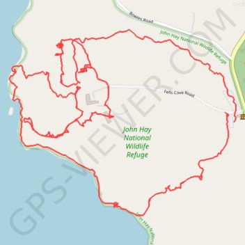
John Hay National Wildlife Refuge
- Distance: 3.4 mi
- Elevation gain: 100 m
- Maximum elevation: 400 m
- Elevation loss: 100 m
- Minimum elevation: 333 m
- Moving time: 2 h 7 m
- Moving speed: 1.6 mph
- Maximum speed: 14.1 mph
- Total time: 2 h 46 m
- Global speed: 1.2 mph
Interactive trail map
Trail profile
- Distance: 3.4 mi
- Elevation gain: 100 m
- Maximum elevation: 400 m
- Elevation loss: 100 m
- Minimum elevation: 333 m
- Moving time: 2 h 7 m
- Moving speed: 1.6 mph
- Maximum speed: 14.1 mph
- Total time: 2 h 46 m
- Global speed: 1.2 mph
About this trail
Name: Trails at The Fells in Newbury NH trail, distance, elevation, map, profile, GPS track
Start: Gatehouse Link, Newbury, Merrimack County, New Hampshire, 03255, United States (43.35139 -72.04128)
End: Gatehouse Link, Newbury, Merrimack County, New Hampshire, 03255, United States (43.35106 -72.04087)
Coordinates: 43.34797 -72.05109 43.35412 -72.04078
Other hiking, mountain biking, running and outdoor activity trails
Click on a trail to view its statistics, map and profile.