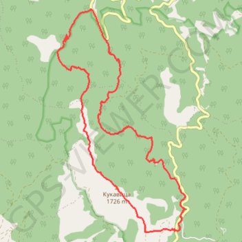
Kopaonik: od Đorovog mosta, Samokovska reka, Kadijevac, vrh ...
- Distance: 11.2 mi
- Elevation gain: 1,119 m
- Maximum elevation: 1,711 m
- Elevation loss: 1,126 m
- Minimum elevation: 693 m
- Moving time: 5 h 8 m
- Moving speed: 2.2 mph
- Maximum speed: 6.4 mph
- Total time: 7 h 19 m
- Global speed: 1.5 mph
Interactive trail map
Trail profile
- Distance: 11.2 mi
- Elevation gain: 1,119 m
- Maximum elevation: 1,711 m
- Elevation loss: 1,126 m
- Minimum elevation: 693 m
- Moving time: 5 h 8 m
- Moving speed: 2.2 mph
- Maximum speed: 6.4 mph
- Total time: 7 h 19 m
- Global speed: 1.5 mph
About this trail
Name: Kopaonik: od Đorovog mosta, Samokovska reka, Kadijevac, vrh ... trail, distance, elevation, map, profile, GPS track
Coordinates: 43.31991 20.72617 43.36640 20.76297
Other hiking, mountain biking, running and outdoor activity trails
Click on a trail to view its statistics, map and profile.
Kopaonik - vrh Kukavica kanjonom Samokovske reke
Serbia > Central Serbia > Raska Administrative District > Raska Municipality > Josanicka Banja > Palješnica
Distance: 11.1 mi • Elevation gain: 1,077 m • Maximum elevation: 1,710 m
2022_Yu
Slovenia > Ajdovščina > Žapuže
Distance: 1,526.9 mi • Elevation gain: 32,048 m • Maximum elevation: 1,950 m
Đorov most - Kadijevac - Kukavica - Kozije stene - Đorov mos...
Serbia > Central Serbia > Raska Administrative District > Raska Municipality > Josanicka Banja
Distance: 10.7 mi • Elevation gain: 1,015 m • Maximum elevation: 1,710 m
Đorov most,Kadijevac,Kukavica,Kozje stene,Mijatovića jaz,Đor...
Serbia > Central Serbia > Raska Administrative District > Raska Municipality > Josanicka Banja > Palješnica
Distance: 11.3 mi • Elevation gain: 1,117 m • Maximum elevation: 1,709 m