Goose Creek State Park
Afternoon hike
- Distance: 5.2 mi
- Elevation gain: 28 m
- Maximum elevation: 7 m
- Elevation loss: 27 m
- Minimum elevation: 0 m
- Moving time: 1 h 45 m
- Moving speed: 3.0 mph
- Maximum speed: 5.5 mph
- Total time: 1 h 53 m
- Global speed: 2.7 mph
Interactive trail map
Trail profile
- Distance: 5.2 mi
- Elevation gain: 28 m
- Maximum elevation: 7 m
- Elevation loss: 27 m
- Minimum elevation: 0 m
- Moving time: 1 h 45 m
- Moving speed: 3.0 mph
- Maximum speed: 5.5 mph
- Total time: 1 h 53 m
- Global speed: 2.7 mph
About this trail
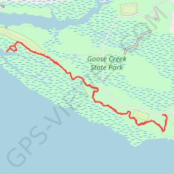
Name: Goose Creek State Park trail, distance, elevation, map, profile, GPS track
Start: Goose Creek Trail, Beaufort County, North Carolina, United States (35.46387 -76.90064)
End: Goose Creek Trail, Beaufort County, North Carolina, United States (35.46390 -76.90017)
Coordinates: 35.46142 -76.92858 35.47450 -76.89980
Other hiking, mountain biking, running and outdoor activity trails
Click on a trail to view its statistics, map and profile.
Goose Creek and Flatty Creek Trail
United States > North Carolina > Beaufort County
Distance: 2.8 mi • Elevation gain: 17 m • Maximum elevation: 7 m
Goose Creek Trail
United States > North Carolina > Beaufort County > Dinah Landing
Distance: 2.4 mi • Elevation gain: 15 m • Maximum elevation: 7 m