Hanakapi'ai Falls (Kauai Island)
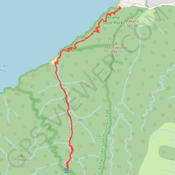
Starting at Kēʻē Beach in Hāʻena State Park, this out-and-back hike follows the Kalalau Trail above the Pacific, leaving the coastal edge of the park to reveal the first broad views of the Nā Pali Coast, with ocean, reef, sea cliffs, and tropical vegetation appearing in succession along the way.
The route then descends toward Hanakāpīʻai Beach, a remote seasonal beach framed by steep green slopes and the mouth of Hanakāpīʻai Valley, before turning inland from the coast onto the Hanakāpīʻai Trail beside the stream.
From there, the hike follows Hanakāpīʻai Stream deeper into the valley, passing through dense rainforest, boulder-strewn sections, shaded pools, and lush volcanic walls before reaching Hanakāpīʻai Falls, a dramatic waterfall set in a secluded amphitheater of dark rock, ferns, and tropical greenery.
#Hiking #Falls #Nature #Forest #River #Coast #Beach #Sea #Pacific #Ocean #Island #Mountain #Hawaii #Wilderness #Park
- Distance: 7.9 mi
- Elevation gain: 1,180 m
- Maximum elevation: 409 m
- Elevation loss: 1,180 m
- Minimum elevation: 10 m
Interactive trail map
Trail profile
- Distance: 7.9 mi
- Elevation gain: 1,180 m
- Maximum elevation: 409 m
- Elevation loss: 1,180 m
- Minimum elevation: 10 m
About this trail
Name: Hanakapi'ai Falls (Kauai Island) trail, distance, elevation, map, profile, GPS track
Start: Kalalau Trail, Kauaʻi County, Hawaii, United States (22.22048 -159.58298)
End: Kalalau Trail, Kauaʻi County, Hawaii, United States (22.22051 -159.58291)
Coordinates: 22.18612 -159.59781 22.22058 -159.58263
Other hiking, mountain biking, running and outdoor activity trails
Click on a trail to view its statistics, map and profile.
Hanakapi'ai Falls via Kalalau Trail and Hanakapi'ai Trail in Nā Pali Coast State Wilderness Park
United States > Hawaii > Kauaʻi County
The hike to Hanakapi'ai Falls is a challenging yet rewarding adventure along Kaua'i’s Nā Pali Coast. Starting from Ke’e Beach, the trail offers a mix of sweeping ocean views and dramatic cliffs, leading you through dense vegetation, bamboo groves, and occasional stream crossings. As you get closer to the…
Distance: 7.9 mi • Elevation gain: 1,114 m • Maximum elevation: 399 m
Kalalau Trail to Hoolea Falls (Kauai Island)
United States > Hawaii > Kauaʻi County
Hike from Ka'ilio Point to Hoolea Falls via Kalalau Trail, Ha'ena State Park, Na Pali Coast State Wilderness Park, The Gate, Hono o Na Pali Natural Area Reserve and Kalalau Beach. #Hiking #Coast #Sea #Pacific #Ocean #Nature #Beach #Forest #Mountain #Volcano #Island #Hawaii
Distance: 19.0 mi • Elevation gain: 3,029 m • Maximum elevation: 224 m