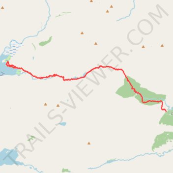
Hike from A Chùil to Sourlies
- Distance: 8.0 mi
- Elevation gain: 377 m
- Maximum elevation: 316 m
- Elevation loss: 473 m
- Minimum elevation: 1 m
- Moving time: 4 h 2 m
- Moving speed: 2.0 mph
- Maximum speed: 3.6 mph
- Total time: 6 h 54 m
- Global speed: 1.2 mph
Interactive trail map
Trail profile
- Distance: 8.0 mi
- Elevation gain: 377 m
- Maximum elevation: 316 m
- Elevation loss: 473 m
- Minimum elevation: 1 m
- Moving time: 4 h 2 m
- Moving speed: 2.0 mph
- Maximum speed: 3.6 mph
- Total time: 6 h 54 m
- Global speed: 1.2 mph
About this trail
Name: Hike from A Chùil to Sourlies trail, distance, elevation, map, profile, GPS track
Start: A' Chùil, Highland, Scotland, United Kingdom (56.97705 -5.38457)
End: Sourlies, Highland, Scotland, United Kingdom (56.99729 -5.51277)
Coordinates: 56.97705 -5.52120 57.00012 -5.38457
Topography: Highland topographic map, elevation, terrain
Other hiking, mountain biking, running and outdoor activity trails
Click on a trail to view its statistics, map and profile.
Hike from Glenfinnan to A Chùil
United Kingdom > Scotland > Highland > Glenfinnan
Distance: 12.6 mi • Elevation gain: 747 m • Maximum elevation: 498 m
Hike from Sourlies to Inverie
United Kingdom > Scotland > Highland
Distance: 9.6 mi • Elevation gain: 639 m • Maximum elevation: 549 m