Peach Orchard Trailhead - Cane Creek Mountains Natural Area
- Distance: 4.9 mi
- Elevation gain: 133 m
- Maximum elevation: 283 m
- Elevation loss: 133 m
- Minimum elevation: 191 m
- Moving time: 2 h 7 m
- Moving speed: 2.3 mph
- Maximum speed: 5.9 mph
- Total time: 2 h 33 m
- Global speed: 1.9 mph
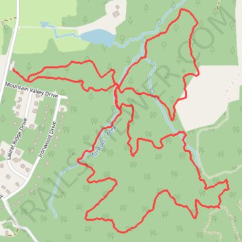
Interactive trail map
Trail profile
- Distance: 4.9 mi
- Elevation gain: 133 m
- Maximum elevation: 283 m
- Elevation loss: 133 m
- Minimum elevation: 191 m
- Moving time: 2 h 7 m
- Moving speed: 2.3 mph
- Maximum speed: 5.9 mph
- Total time: 2 h 33 m
- Global speed: 1.9 mph
About this trail
Name: Peach Orchard Trailhead - Cane Creek Mountains Natural Area trail, distance, elevation, map, profile, GPS track
Start: Peach Orchard Trailhead Parking, Alamance County, North Carolina, United States (35.95602 -79.44485)
End: Peach Orchard Trailhead Parking, Alamance County, North Carolina, United States (35.95601 -79.44485)
Coordinates: 35.94747 -79.44485 35.95919 -79.43091
Other hiking, mountain biking, running and outdoor activity trails
Click on a trail to view its statistics, map and profile.
Pioneer Trail at Cane Creek Mountains Natural Area
United States > North Carolina > Alamance County
Distance: 3.4 mi • Elevation gain: 99 m • Maximum elevation: 285 m
Pioneer Camp Trail (purple) loop hike
United States > North Carolina > Alamance County
Distance: 3.6 mi • Elevation gain: 105 m • Maximum elevation: 286 m