Thank you for supporting this site ❤️
Make a donation
Make a donation
Gear up for your next adventure:
As an Amazon Associate, this site earns from qualifying purchases at no extra cost to you.
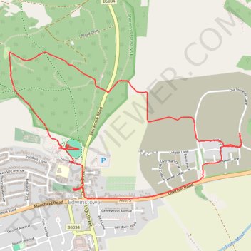
Edwinstowe Loop Walk
- Distance: 3.4 mi
- Elevation gain: 50 m
- Maximum elevation: 81 m
- Elevation loss: 49 m
- Minimum elevation: 53 m
- Moving time: 1 h 40 m
- Moving speed: 2.0 mph
- Maximum speed: 7.9 mph
- Total time: 2 h 35 m
- Global speed: 1.3 mph
Interactive trail map
Thank you for supporting this site ❤️
Make a donation
Make a donation
Gear up for your next adventure:
As an Amazon Associate, this site earns from qualifying purchases at no extra cost to you.
Trail profile
- Distance: 3.4 mi
- Elevation gain: 50 m
- Maximum elevation: 81 m
- Elevation loss: 49 m
- Minimum elevation: 53 m
- Moving time: 1 h 40 m
- Moving speed: 2.0 mph
- Maximum speed: 7.9 mph
- Total time: 2 h 35 m
- Global speed: 1.3 mph
Thank you for supporting this site ❤️
Make a donation
Make a donation
Gear up for your next adventure:
As an Amazon Associate, this site earns from qualifying purchases at no extra cost to you.
About this trail
Name: Edwinstowe Loop Walk trail, distance, elevation, map, profile, GPS track
Coordinates: 53.19524 -1.07237 53.20435 -1.04823
Topography: Newark and Sherwood topographic map, elevation, terrain
Thank you for supporting this site ❤️
Make a donation
Make a donation
Gear up for your next adventure:
As an Amazon Associate, this site earns from qualifying purchases at no extra cost to you.