Thank you for supporting this site ❤️
Make a donation
Make a donation
Gear up for your next adventure:
As an Amazon Associate, this site earns from qualifying purchases at no extra cost to you.
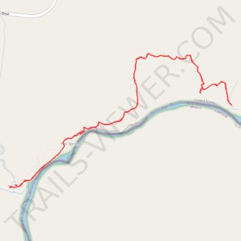
Rio Grande Village to Hot Springs out and back
- Distance: 6.2 mi
- Elevation gain: 293 m
- Maximum elevation: 668 m
- Elevation loss: 293 m
- Minimum elevation: 562 m
- Moving time: 3 h 10 m
- Moving speed: 1.9 mph
- Maximum speed: 3.3 mph
- Total time: 4 h 34 m
- Global speed: 1.4 mph
Interactive trail map
Thank you for supporting this site ❤️
Make a donation
Make a donation
Gear up for your next adventure:
As an Amazon Associate, this site earns from qualifying purchases at no extra cost to you.
Trail profile
- Distance: 6.2 mi
- Elevation gain: 293 m
- Maximum elevation: 668 m
- Elevation loss: 293 m
- Minimum elevation: 562 m
- Moving time: 3 h 10 m
- Moving speed: 1.9 mph
- Maximum speed: 3.3 mph
- Total time: 4 h 34 m
- Global speed: 1.4 mph
Thank you for supporting this site ❤️
Make a donation
Make a donation
Gear up for your next adventure:
As an Amazon Associate, this site earns from qualifying purchases at no extra cost to you.
About this trail
Name: Rio Grande Village to Hot Springs out and back trail, distance, elevation, map, profile, GPS track
Start: Daniels Ranch Road, Rio Grande Village, Brewster County, Texas, United States (29.18621 -102.97241)
End: Daniels Ranch Road, Rio Grande Village, Brewster County, Texas, United States (29.18622 -102.97243)
Coordinates: 29.17740 -102.99972 29.19178 -102.97241
Thank you for supporting this site ❤️
Make a donation
Make a donation
Gear up for your next adventure:
As an Amazon Associate, this site earns from qualifying purchases at no extra cost to you.