Thank you for supporting this site ❤️
Make a donation
Make a donation
Gear up for your next adventure:
As an Amazon Associate, this site earns from qualifying purchases at no extra cost to you.
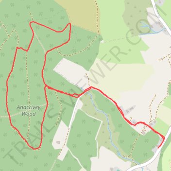
Blackhouse Lane and Anacrivey woods loop
- Distance: 3.2 mi
- Elevation gain: 175 m
- Maximum elevation: 373 m
- Elevation loss: 173 m
- Minimum elevation: 208 m
- Moving time: 1 h 7 m
- Moving speed: 2.8 mph
- Maximum speed: 7.5 mph
- Total time: 1 h 15 m
- Global speed: 2.5 mph
Interactive trail map
Thank you for supporting this site ❤️
Make a donation
Make a donation
Gear up for your next adventure:
As an Amazon Associate, this site earns from qualifying purchases at no extra cost to you.
Trail profile
- Distance: 3.2 mi
- Elevation gain: 175 m
- Maximum elevation: 373 m
- Elevation loss: 173 m
- Minimum elevation: 208 m
- Moving time: 1 h 7 m
- Moving speed: 2.8 mph
- Maximum speed: 7.5 mph
- Total time: 1 h 15 m
- Global speed: 2.5 mph
Thank you for supporting this site ❤️
Make a donation
Make a donation
Gear up for your next adventure:
As an Amazon Associate, this site earns from qualifying purchases at no extra cost to you.
About this trail
Name: Blackhouse Lane and Anacrivey woods loop trail, distance, elevation, map, profile, GPS track
Coordinates: 53.19207 -6.21837 53.20086 -6.20012
Thank you for supporting this site ❤️
Make a donation
Make a donation
Gear up for your next adventure:
As an Amazon Associate, this site earns from qualifying purchases at no extra cost to you.
Other hiking, mountain biking, running and outdoor activity trails
Click on a trail to view its statistics, map and profile.