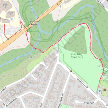
John Okey Davis Park
- Distance: 0.8 mi
- Elevation gain: 8 m
- Maximum elevation: 18 m
- Elevation loss: 12 m
- Minimum elevation: 8 m
- Moving time: 13 m 42 s
- Moving speed: 3.3 mph
- Maximum speed: 5.1 mph
- Total time: 13 m 42 s
- Global speed: 3.3 mph
Interactive trail map
Trail profile
- Distance: 0.8 mi
- Elevation gain: 8 m
- Maximum elevation: 18 m
- Elevation loss: 12 m
- Minimum elevation: 8 m
- Moving time: 13 m 42 s
- Moving speed: 3.3 mph
- Maximum speed: 5.1 mph
- Total time: 13 m 42 s
- Global speed: 3.3 mph
About this trail
Name: John Okey Davis Park trail, distance, elevation, map, profile, GPS track
Start: Homestead Road, Gosnells, City of Gosnells, Western Australia, 6108, Australia (-32.06375 115.98159)
Coordinates: -32.06375 115.97564 -32.06025 115.98188