Thank you for supporting this site ❤️
Make a donation
Make a donation
Gear up for your next adventure:
As an Amazon Associate, this site earns from qualifying purchases at no extra cost to you.
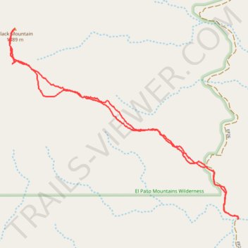
Black Mountain Hike (El Paso Mountains Wilderness)
- Distance: 3.6 mi
- Elevation gain: 493 m
- Maximum elevation: 1,594 m
- Elevation loss: 493 m
- Minimum elevation: 1,100 m
- Moving time: 2 h 16 m
- Moving speed: 1.6 mph
- Maximum speed: 3.5 mph
- Total time: 4 h 1 m
- Global speed: 0.9 mph
Interactive trail map
Thank you for supporting this site ❤️
Make a donation
Make a donation
Gear up for your next adventure:
As an Amazon Associate, this site earns from qualifying purchases at no extra cost to you.
Trail profile
- Distance: 3.6 mi
- Elevation gain: 493 m
- Maximum elevation: 1,594 m
- Elevation loss: 493 m
- Minimum elevation: 1,100 m
- Moving time: 2 h 16 m
- Moving speed: 1.6 mph
- Maximum speed: 3.5 mph
- Total time: 4 h 1 m
- Global speed: 0.9 mph
Thank you for supporting this site ❤️
Make a donation
Make a donation
Gear up for your next adventure:
As an Amazon Associate, this site earns from qualifying purchases at no extra cost to you.
About this trail
Name: Black Mountain Hike (El Paso Mountains Wilderness) trail, distance, elevation, map, profile, GPS track
Start: EP26, Kern County, California, United States (35.46150 -117.82301)
End: EP26, Kern County, California, United States (35.46148 -117.82293)
Coordinates: 35.46148 -117.84294 35.47507 -117.82289
Thank you for supporting this site ❤️
Make a donation
Make a donation
Gear up for your next adventure:
As an Amazon Associate, this site earns from qualifying purchases at no extra cost to you.