Tysoe ➡️ Epwell ➡️ Shenington
- Distance: 10.2 mi
- Elevation gain: 283 m
- Maximum elevation: 222 m
- Elevation loss: 283 m
- Minimum elevation: 108 m
- Moving time: 1 h 40 m
- Moving speed: 6.1 mph
- Maximum speed: 11.7 mph
- Total time: 1 h 40 m
- Global speed: 6.1 mph
Interactive trail map
Trail profile
- Distance: 10.2 mi
- Elevation gain: 283 m
- Maximum elevation: 222 m
- Elevation loss: 283 m
- Minimum elevation: 108 m
- Moving time: 1 h 40 m
- Moving speed: 6.1 mph
- Maximum speed: 11.7 mph
- Total time: 1 h 40 m
- Global speed: 6.1 mph
About this trail
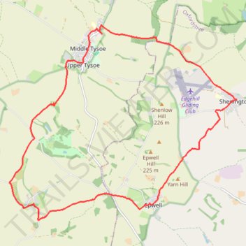
Name: Tysoe ➡️ Epwell ➡️ Shenington trail, distance, elevation, map, profile, GPS track
Coordinates: 52.05847 -1.53214 52.09727 -1.45846
Topography: Stratford-on-Avon topographic map, elevation, terrain
Other hiking, mountain biking, running and outdoor activity trails
Click on a trail to view its statistics, map and profile.
Loop from Tysoe via Burdrop and Brailles in The Cotswolds National Landscape
United Kingdom > England > Warwickshire > Stratford-on-Avon > Middle Tysoe
Distance: 15.8 mi • Elevation gain: 459 m • Maximum elevation: 214 m
Ratley Radway Lwr Tysoe Alkerton Hornton trailrun route
United Kingdom > England > Warwickshire > Stratford-on-Avon > Ratley
Morning Run
Distance: 11.9 mi • Elevation gain: 412 m • Maximum elevation: 218 m