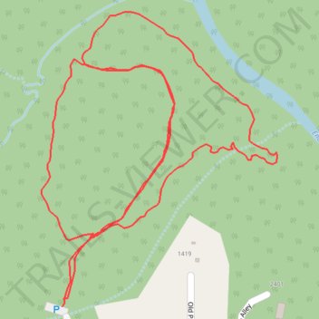
Trails in Panther Branch Natural Area
- Distance: 1.5 mi
- Elevation gain: 19 m
- Maximum elevation: 189 m
- Elevation loss: 19 m
- Minimum elevation: 178 m
- Moving time: 26 m 37 s
- Moving speed: 3.5 mph
- Maximum speed: 5.0 mph
- Total time: 29 m 25 s
- Global speed: 3.1 mph
Interactive trail map
Trail profile
- Distance: 1.5 mi
- Elevation gain: 19 m
- Maximum elevation: 189 m
- Elevation loss: 19 m
- Minimum elevation: 178 m
- Moving time: 26 m 37 s
- Moving speed: 3.5 mph
- Maximum speed: 5.0 mph
- Total time: 29 m 25 s
- Global speed: 3.1 mph
About this trail
Name: Trails in Panther Branch Natural Area trail, distance, elevation, map, profile, GPS track
Coordinates: 36.10266 -79.15048 36.10689 -79.14629