Panorama Loop (long)
- Distance: 10.3 mi
- Elevation gain: 559 m
- Maximum elevation: 443 m
- Elevation loss: 559 m
- Minimum elevation: 206 m
- Moving time: 1 h 3 m
- Moving speed: 9.7 mph
- Maximum speed: 27.1 mph
- Total time: 1 h 8 m
- Global speed: 9.1 mph
Interactive trail map
Trail profile
- Distance: 10.3 mi
- Elevation gain: 559 m
- Maximum elevation: 443 m
- Elevation loss: 559 m
- Minimum elevation: 206 m
- Moving time: 1 h 3 m
- Moving speed: 9.7 mph
- Maximum speed: 27.1 mph
- Total time: 1 h 8 m
- Global speed: 9.1 mph
About this trail
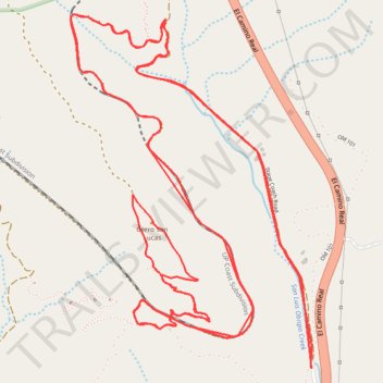
Name: Panorama Loop (long) trail, distance, elevation, map, profile, GPS track
Start: Stage Coach Road, San Luis Obispo County, California, 93410, United States (35.31886 -120.62199)
End: Stage Coach Road, San Luis Obispo County, California, 93410, United States (35.31882 -120.62196)
Coordinates: 35.31882 -120.63705 35.33693 -120.62192