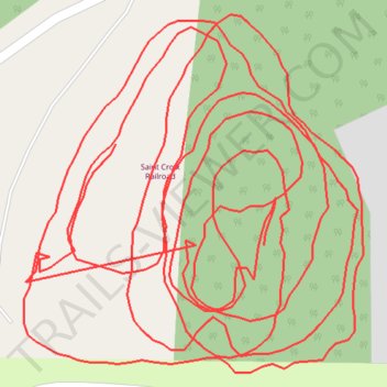
Saint Croix Railroad
- Distance: 1.7 mi
- Elevation gain: 22 m
- Maximum elevation: 274 m
- Elevation loss: 19 m
- Minimum elevation: 265 m
- Moving time: 53 m 19 s
- Moving speed: 1.9 mph
- Maximum speed: 10.5 mph
- Total time: 1 h 29 s
- Global speed: 1.7 mph
Interactive trail map
Trail profile
- Distance: 1.7 mi
- Elevation gain: 22 m
- Maximum elevation: 274 m
- Elevation loss: 19 m
- Minimum elevation: 265 m
- Moving time: 53 m 19 s
- Moving speed: 1.9 mph
- Maximum speed: 10.5 mph
- Total time: 1 h 29 s
- Global speed: 1.7 mph
About this trail
Name: Saint Croix Railroad trail, distance, elevation, map, profile, GPS track
Coordinates: 44.90561 -92.73988 44.90735 -92.73755