Thank you for supporting this site ❤️
Make a donation
Make a donation
Gear up for your next adventure:
As an Amazon Associate, this site earns from qualifying purchases at no extra cost to you.
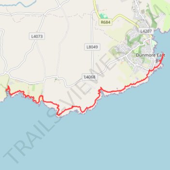
Ballymacaw and Dunmore East cliff walk
- Distance: 5.1 mi
- Elevation gain: 230 m
- Maximum elevation: 39 m
- Elevation loss: 228 m
- Minimum elevation: 0 m
- Moving time: 2 h 5 m
- Moving speed: 2.5 mph
- Maximum speed: 4.9 mph
- Total time: 2 h 19 m
- Global speed: 2.2 mph
Interactive trail map
Thank you for supporting this site ❤️
Make a donation
Make a donation
Gear up for your next adventure:
As an Amazon Associate, this site earns from qualifying purchases at no extra cost to you.
Trail profile
- Distance: 5.1 mi
- Elevation gain: 230 m
- Maximum elevation: 39 m
- Elevation loss: 228 m
- Minimum elevation: 0 m
- Moving time: 2 h 5 m
- Moving speed: 2.5 mph
- Maximum speed: 4.9 mph
- Total time: 2 h 19 m
- Global speed: 2.2 mph
Thank you for supporting this site ❤️
Make a donation
Make a donation
Gear up for your next adventure:
As an Amazon Associate, this site earns from qualifying purchases at no extra cost to you.
About this trail
Name: Ballymacaw and Dunmore East cliff walk trail, distance, elevation, map, profile, GPS track
Coordinates: 52.13296 -7.05645 52.14894 -6.98916
Thank you for supporting this site ❤️
Make a donation
Make a donation
Gear up for your next adventure:
As an Amazon Associate, this site earns from qualifying purchases at no extra cost to you.