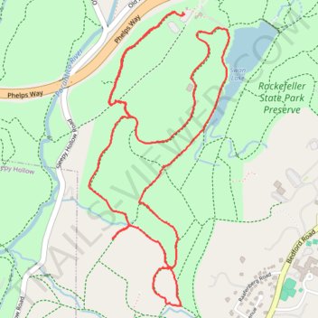
Rockefeller State Park Preserve
- Distance: 4.2 mi
- Elevation gain: 117 m
- Maximum elevation: 125 m
- Elevation loss: 118 m
- Minimum elevation: 79 m
- Moving time: 1 h 19 m
- Moving speed: 3.1 mph
- Maximum speed: 4.2 mph
- Total time: 1 h 23 m
- Global speed: 3.0 mph
Interactive trail map
Trail profile
- Distance: 4.2 mi
- Elevation gain: 117 m
- Maximum elevation: 125 m
- Elevation loss: 118 m
- Minimum elevation: 79 m
- Moving time: 1 h 19 m
- Moving speed: 3.1 mph
- Maximum speed: 4.2 mph
- Total time: 1 h 23 m
- Global speed: 3.0 mph
About this trail
Name: Rockefeller State Park Preserve trail, distance, elevation, map, profile, GPS track
Coordinates: 41.09746 -73.84343 41.11185 -73.83434
Other hiking, mountain biking, running and outdoor activity trails
Click on a trail to view its statistics, map and profile.
Pocantico Lake County Park - White Trail and Dam
United States > New York > Westchester County > Town of Mount Pleasant
Distance: 3.5 mi • Elevation gain: 101 m • Maximum elevation: 110 m
Rockefeller State Park loop hike
United States > New York > Westchester County > Village of Sleepy Hollow
Distance: 6.8 mi • Elevation gain: 184 m • Maximum elevation: 157 m
Rockefeller State Park trails
United States > New York > Westchester County > Town of Mount Pleasant
Distance: 6.3 mi • Elevation gain: 220 m • Maximum elevation: 135 m