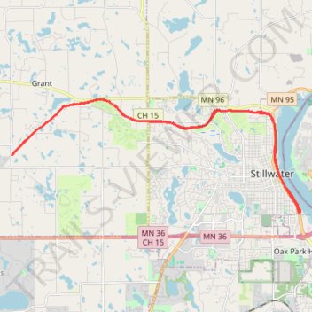
Brown's Creek State Trail
- Distance: 17.6 mi
- Elevation gain: 218 m
- Maximum elevation: 311 m
- Elevation loss: 218 m
- Minimum elevation: 207 m
- Moving time: 1 h 17 m
- Moving speed: 13.6 mph
- Maximum speed: 25.8 mph
- Total time: 1 h 17 m
- Global speed: 13.6 mph
Interactive trail map
Trail profile
- Distance: 17.6 mi
- Elevation gain: 218 m
- Maximum elevation: 311 m
- Elevation loss: 218 m
- Minimum elevation: 207 m
- Moving time: 1 h 17 m
- Moving speed: 13.6 mph
- Maximum speed: 25.8 mph
- Total time: 1 h 17 m
- Global speed: 13.6 mph
About this trail
Name: Brown's Creek State Trail trail, distance, elevation, map, profile, GPS track
Coordinates: 45.04344 -92.92388 45.07916 -92.79495
Other hiking, mountain biking, running and outdoor activity trails
Click on a trail to view its statistics, map and profile.
Fairy Falls trail
United States > Minnesota > Washington County > Stillwater Township
Distance: 1.5 mi • Elevation gain: 73 m • Maximum elevation: 255 m