Mammoth Lakes Loop
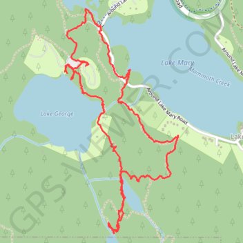
Loop hike via Lake Mary, Lake Barret, T J Lake, Lake George, Lake Mamie and Mammoth Creek in the Inyo National Forest. #Hiking #Loop #Lake #Forest #Nature #River #Mountain
- Distance: 3.3 mi
- Elevation gain: 159 m
- Maximum elevation: 2,842 m
- Elevation loss: 156 m
- Minimum elevation: 2,715 m
- Moving time: 1 h 18 m
- Moving speed: 2.6 mph
- Maximum speed: 22.8 mph
- Total time: 1 h 39 m
- Global speed: 2.0 mph
Interactive trail map
Trail profile
- Distance: 3.3 mi
- Elevation gain: 159 m
- Maximum elevation: 2,842 m
- Elevation loss: 156 m
- Minimum elevation: 2,715 m
- Moving time: 1 h 18 m
- Moving speed: 2.6 mph
- Maximum speed: 22.8 mph
- Total time: 1 h 39 m
- Global speed: 2.0 mph
About this trail
Name: Mammoth Lakes Loop trail, distance, elevation, map, profile, GPS track
Coordinates: 37.59359 -119.01148 37.60622 -119.00340
Other hiking, mountain biking, running and outdoor activity trails
Click on a trail to view its statistics, map and profile.
Gravel bike ride around Mammoth Lakes
United States > California > Mono County
Distance: 33.8 mi • Elevation gain: 1,038 m • Maximum elevation: 2,739 m