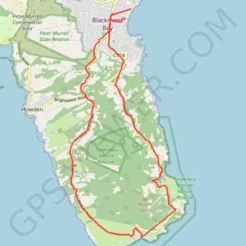
Import a GPX file

Tinderbox Circuit

#Bike #Loop #Tasmania

  • Distance: 11.1 mi
  • Elevation gain: 427 m
  • Maximum elevation: 138 m
  • Elevation loss: 424 m
  • Minimum elevation: 0 m

Interactive trail map

Trail profile

  • Distance: 11.1 mi
  • Elevation gain: 427 m
  • Maximum elevation: 138 m
  • Elevation loss: 424 m
  • Minimum elevation: 0 m

About this trail

Gear up for your next adventure:

🎿Telescopic Trekking Poles - Reduces knee strain on steep topographic descents
🔭Compact Hiking Binoculars - Lightweight optics for scouting terrain and spotting wildlife
🚲Cycling GPS Computers - Track elevation and topographic routes on two wheels
🧢Waterproof Hiking Hats - Keep the rain off your face while studying topographic maps
🧰Survival Kits - Emergency tools for remote environments

As an Amazon Associate, this site earns from qualifying purchases at no extra cost to you.