Thank you for supporting this site ❤️
Make a donation
Make a donation
Gear up for your next adventure:
As an Amazon Associate, this site earns from qualifying purchases at no extra cost to you.
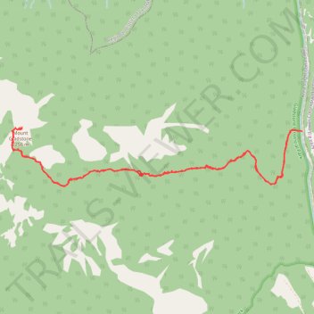
Mount Gladstone hiking trail
- Distance: 8.8 mi
- Elevation gain: 1,112 m
- Maximum elevation: 2,244 m
- Elevation loss: 1,110 m
- Minimum elevation: 1,160 m
- Moving time: 4 h 51 m
- Moving speed: 1.8 mph
- Maximum speed: 12.7 mph
- Total time: 7 h 29 m
- Global speed: 1.2 mph
Interactive trail map
Thank you for supporting this site ❤️
Make a donation
Make a donation
Gear up for your next adventure:
As an Amazon Associate, this site earns from qualifying purchases at no extra cost to you.
Trail profile
- Distance: 8.8 mi
- Elevation gain: 1,112 m
- Maximum elevation: 2,244 m
- Elevation loss: 1,110 m
- Minimum elevation: 1,160 m
- Moving time: 4 h 51 m
- Moving speed: 1.8 mph
- Maximum speed: 12.7 mph
- Total time: 7 h 29 m
- Global speed: 1.2 mph
Thank you for supporting this site ❤️
Make a donation
Make a donation
Gear up for your next adventure:
As an Amazon Associate, this site earns from qualifying purchases at no extra cost to you.
About this trail
Name: Mount Gladstone hiking trail trail, distance, elevation, map, profile, GPS track
Coordinates: 49.22906 -118.18664 49.23597 -118.13448
Thank you for supporting this site ❤️
Make a donation
Make a donation
Gear up for your next adventure:
As an Amazon Associate, this site earns from qualifying purchases at no extra cost to you.
Other hiking, mountain biking, running and outdoor activity trails
Click on a trail to view its statistics, map and profile.