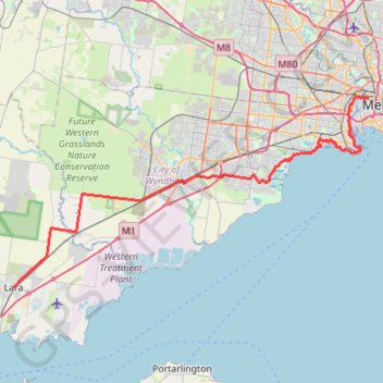
Import a GPX file

Melbourne - Lara

Hobsons Bay Coatal Trail. #Bike #Melbourne

  • Distance: 48.5 mi
  • Elevation gain: 243 m
  • Maximum elevation: 55 m
  • Elevation loss: 229 m
  • Minimum elevation: -1 m

Interactive trail map

Trail profile

  • Distance: 48.5 mi
  • Elevation gain: 243 m
  • Maximum elevation: 55 m
  • Elevation loss: 229 m
  • Minimum elevation: -1 m

About this trail

Other hiking, mountain biking, running and outdoor activity trails

Click on a trail to view its statistics, map and profile.

You Yangs Circuit - Flinders Peak

Australia > Victoria > Little River

#Hiking #Loop #YouYangs

Distance: 6.5 mi • Elevation gain: 428 m • Maximum elevation: 335 m

Port Melbourne Loop

Australia > Victoria > Melbourne

#Bike #Loop #Melbourne

Distance: 11.7 mi • Elevation gain: 213 m • Maximum elevation: 55 m

Gear up for your next adventure:

📸Action Camera Chest Mounts - Record your ascent following topographic paths hands-free
🧊Insulated Flasks - Keeps drinks hot or cold during hikes
🎒Hiking Daypacks - Compact backpacks ideal for short hikes and excursions
🗺️Topographic Maps - Detailed maps showing elevation and terrain features
GPS Outdoor Watches - Watches with GPS tracking for hiking and exploration

As an Amazon Associate, this site earns from qualifying purchases at no extra cost to you.