Barwon River
Interactive trail map
Trail profile
- Distance: 15.2 mi
- Elevation gain: 206 m
- Maximum elevation: 35 m
- Elevation loss: 206 m
- Minimum elevation: 3 m
About this trail
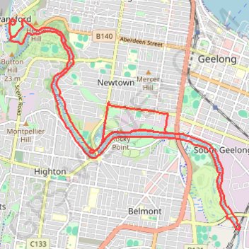
Name: Barwon River trail, distance, elevation, map, profile, GPS track
Coordinates: -38.18214 144.30910 -38.14176 144.36530
Other hiking, mountain biking, running and outdoor activity trails
Click on a trail to view its statistics, map and profile.
Geelong - Queenscliff
Australia > Victoria > Geelong
#Bike
Distance: 21.6 mi • Elevation gain: 176 m • Maximum elevation: 83 m