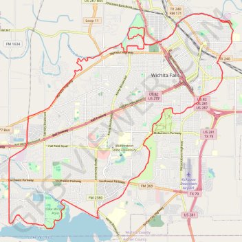
Wichita Falls Loop
- Distance: 27.8 mi
- Elevation gain: 185 m
- Maximum elevation: 319 m
- Elevation loss: 184 m
- Minimum elevation: 283 m
- Moving time: 2 h 19 m
- Moving speed: 12.0 mph
- Maximum speed: 22.2 mph
- Total time: 2 h 27 m
- Global speed: 11.3 mph
Interactive trail map
Trail profile
- Distance: 27.8 mi
- Elevation gain: 185 m
- Maximum elevation: 319 m
- Elevation loss: 184 m
- Minimum elevation: 283 m
- Moving time: 2 h 19 m
- Moving speed: 12.0 mph
- Maximum speed: 22.2 mph
- Total time: 2 h 27 m
- Global speed: 11.3 mph
About this trail
Name: Wichita Falls Loop trail, distance, elevation, map, profile, GPS track
Start: Williams Park Drive, Wichita Falls, Wichita County, Texas, 76303, United States (33.92115 -98.46960)
End: Williams Park Drive, Wichita Falls, Wichita County, Texas, 76303, United States (33.92245 -98.47433)
Coordinates: 33.83841 -98.57818 33.92535 -98.46917