USA NY Adirondacks Jay Range Saddleback unmaintained path
NY Saddleback in Jay
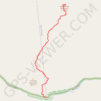
- Distance: 3.6 mi
- Elevation gain: 405 m
- Maximum elevation: 1,089 m
- Elevation loss: 405 m
- Minimum elevation: 714 m
- Moving time: 2 h 33 m
- Moving speed: 1.4 mph
- Maximum speed: 6.2 mph
- Total time: 6 h 21 m
- Global speed: 0.6 mph
Interactive trail map
Trail profile
- Distance: 3.6 mi
- Elevation gain: 405 m
- Maximum elevation: 1,089 m
- Elevation loss: 405 m
- Minimum elevation: 714 m
- Moving time: 2 h 33 m
- Moving speed: 1.4 mph
- Maximum speed: 6.2 mph
- Total time: 6 h 21 m
- Global speed: 0.6 mph
About this trail
Name: USA NY Adirondacks Jay Range Saddleback unmaintained path trail, distance, elevation, map, profile, GPS track
Start: Wells Hill Road, Town of Jay, Essex County, New York, United States (44.27876 -73.67294)
End: Wells Hill Road, Town of Lewis, Essex County, New York, United States (44.27877 -73.67265)
Coordinates: 44.27873 -73.67554 44.29519 -73.66785
Other hiking, mountain biking, running and outdoor activity trails
Click on a trail to view its statistics, map and profile.