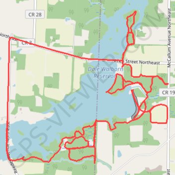
Trails at Walborn Reservoir, as traversed on MTB
Getting dirty at Walborn
- Distance: 12.2 mi
- Elevation gain: 180 m
- Maximum elevation: 356 m
- Elevation loss: 180 m
- Minimum elevation: 323 m
- Moving time: 1 h 16 m
- Moving speed: 9.5 mph
- Maximum speed: 24.3 mph
- Total time: 1 h 20 m
- Global speed: 9.1 mph
Interactive trail map
Trail profile
- Distance: 12.2 mi
- Elevation gain: 180 m
- Maximum elevation: 356 m
- Elevation loss: 180 m
- Minimum elevation: 323 m
- Moving time: 1 h 16 m
- Moving speed: 9.5 mph
- Maximum speed: 24.3 mph
- Total time: 1 h 20 m
- Global speed: 9.1 mph
About this trail
Name: Trails at Walborn Reservoir, as traversed on MTB trail, distance, elevation, map, profile, GPS track
Start: Shoreline Trail, Marlboro Township, Stark County, Ohio, United States (40.96502 -81.19958)
Coordinates: 40.96452 -81.20046 40.98463 -81.17220
Other hiking, mountain biking, running and outdoor activity trails
Click on a trail to view its statistics, map and profile.