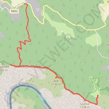
Kanjon Drine - Pogledala - Bijele Vode
- Distance: 11.7 mi
- Elevation gain: 1,238 m
- Maximum elevation: 1,219 m
- Elevation loss: 986 m
- Minimum elevation: 727 m
- Moving time: 5 h 48 m
- Moving speed: 2.0 mph
- Maximum speed: 21.9 mph
- Total time: 9 h 53 m
- Global speed: 1.2 mph
Interactive trail map
Trail profile
- Distance: 11.7 mi
- Elevation gain: 1,238 m
- Maximum elevation: 1,219 m
- Elevation loss: 986 m
- Minimum elevation: 727 m
- Moving time: 5 h 48 m
- Moving speed: 2.0 mph
- Maximum speed: 21.9 mph
- Total time: 9 h 53 m
- Global speed: 1.2 mph
About this trail
Name: Kanjon Drine - Pogledala - Bijele Vode trail, distance, elevation, map, profile, GPS track
End: Podravanje, Srebrenica municipality, Republika Srpska, Bosnia and Herzegovina (44.02794 19.24075)
Coordinates: 44.00630 19.23529 44.05066 19.28889
Other hiking, mountain biking, running and outdoor activity trails
Click on a trail to view its statistics, map and profile.
2022_Yu
Slovenia > Ajdovščina > Žapuže
Distance: 1,526.9 mi • Elevation gain: 32,048 m • Maximum elevation: 1,950 m