Hillwalk Scafell Pike
Hillwalk, Scafell, Pike, Sca, Fell
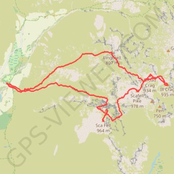
- Distance: 8.6 mi
- Elevation gain: 1,404 m
- Maximum elevation: 970 m
- Elevation loss: 1,405 m
- Minimum elevation: 73 m
- Moving time: 5 h 35 m
- Moving speed: 1.5 mph
- Maximum speed: 4.1 mph
- Total time: 6 h 51 m
- Global speed: 1.3 mph
Interactive trail map
Trail profile
- Distance: 8.6 mi
- Elevation gain: 1,404 m
- Maximum elevation: 970 m
- Elevation loss: 1,405 m
- Minimum elevation: 73 m
- Moving time: 5 h 35 m
- Moving speed: 1.5 mph
- Maximum speed: 4.1 mph
- Total time: 6 h 51 m
- Global speed: 1.3 mph
About this trail
Name: Hillwalk Scafell Pike trail, distance, elevation, map, profile, GPS track
Coordinates: 54.44717 -3.26224 54.46300 -3.19968
Topography: Cumberland topographic map, elevation, terrain
Other hiking, mountain biking, running and outdoor activity trails
Click on a trail to view its statistics, map and profile.
Sca Fell via Lord's Rake and West Wall Traverse
United Kingdom > England > Cumberland
Distance: 6.9 mi • Elevation gain: 1,207 m • Maximum elevation: 970 m
Scafell Pike from Wasdale
United Kingdom > England > Cumberland
Distance: 5.4 mi • Elevation gain: 902 m • Maximum elevation: 970 m