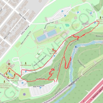
Nay Aug Park Loop
- Distance: 1.5 mi
- Elevation gain: 42 m
- Maximum elevation: 304 m
- Elevation loss: 41 m
- Minimum elevation: 276 m
- Moving time: 37 m 56 s
- Moving speed: 2.3 mph
- Maximum speed: 9.6 mph
- Total time: 53 m 54 s
- Global speed: 1.6 mph
Interactive trail map
Trail profile
- Distance: 1.5 mi
- Elevation gain: 42 m
- Maximum elevation: 304 m
- Elevation loss: 41 m
- Minimum elevation: 276 m
- Moving time: 37 m 56 s
- Moving speed: 2.3 mph
- Maximum speed: 9.6 mph
- Total time: 53 m 54 s
- Global speed: 1.6 mph
About this trail
Name: Nay Aug Park Loop trail, distance, elevation, map, profile, GPS track
Start: Davis Trail, Scranton, Lackawanna County, Pennsylvania, 18510, United States (41.39969 -75.64092)
End: Davis Trail, Scranton, Lackawanna County, Pennsylvania, 18510, United States (41.39968 -75.64104)
Coordinates: 41.39968 -75.64456 41.40285 -75.63798