Make a donation
Gear up for your next adventure:
As an Amazon Associate, this site earns from qualifying purchases at no extra cost to you.
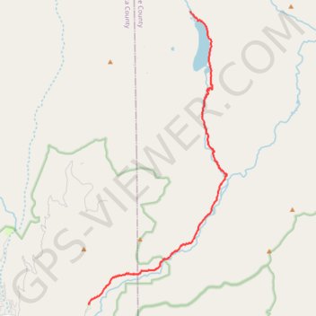
Emerald Lake via Pine River and Lake Creek - Weminuche Wilderness
Wilderness hike
- Distance: 12.3 mi
- Elevation gain: 863 m
- Maximum elevation: 3,107 m
- Elevation loss: 210 m
- Minimum elevation: 2,411 m
- Moving time: 6 h 16 m
- Moving speed: 2.0 mph
- Maximum speed: 3.7 mph
- Total time: 7 h 35 m
- Global speed: 1.6 mph
Interactive trail map
Make a donation
Gear up for your next adventure:
As an Amazon Associate, this site earns from qualifying purchases at no extra cost to you.
Trail profile
- Distance: 12.3 mi
- Elevation gain: 863 m
- Maximum elevation: 3,107 m
- Elevation loss: 210 m
- Minimum elevation: 2,411 m
- Moving time: 6 h 16 m
- Moving speed: 2.0 mph
- Maximum speed: 3.7 mph
- Total time: 7 h 35 m
- Global speed: 1.6 mph
Make a donation
Gear up for your next adventure:
As an Amazon Associate, this site earns from qualifying purchases at no extra cost to you.
About this trail
Name: Emerald Lake via Pine River and Lake Creek - Weminuche Wilderness trail, distance, elevation, map, profile, GPS track
End: Lake Fork Trail (528), Hinsdale County, Colorado, United States (37.56774 -107.45256)
Coordinates: 37.44700 -107.50524 37.56774 -107.43327
Make a donation
Gear up for your next adventure:
As an Amazon Associate, this site earns from qualifying purchases at no extra cost to you.
Other hiking, mountain biking, running and outdoor activity trails
Click on a trail to view its statistics, map and profile.
Rock Creek Down
United States > Colorado > Hinsdale County
Wilderness hike
Distance: 11.0 mi • Elevation gain: 758 m • Maximum elevation: 3,812 m
Lake Creek Down
United States > Colorado > Hinsdale County
Distance: 10.5 mi • Elevation gain: 132 m • Maximum elevation: 3,557 m