Wiwaxy East Peak - Yukness Mountain - Yukness NW - Mount Schaffer
Scrambling, mountain, peak
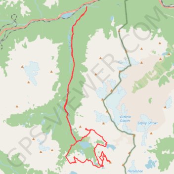
- Distance: 26.0 mi
- Elevation gain: 2,791 m
- Maximum elevation: 2,838 m
- Elevation loss: 2,792 m
- Minimum elevation: 1,599 m
- Moving time: 11 h 58 m
- Moving speed: 2.2 mph
- Maximum speed: 9.3 mph
- Total time: 16 h 52 m
- Global speed: 1.5 mph
Interactive trail map
Trail profile
- Distance: 26.0 mi
- Elevation gain: 2,791 m
- Maximum elevation: 2,838 m
- Elevation loss: 2,792 m
- Minimum elevation: 1,599 m
- Moving time: 11 h 58 m
- Moving speed: 2.2 mph
- Maximum speed: 9.3 mph
- Total time: 16 h 52 m
- Global speed: 1.5 mph
About this trail
Name: Wiwaxy East Peak - Yukness Mountain - Yukness NW - Mount Schaffer trail, distance, elevation, map, profile, GPS track
Coordinates: 51.34108 -116.35240 51.44509 -116.30487
Other hiking, mountain biking, running and outdoor activity trails
Click on a trail to view its statistics, map and profile.