Thank you for supporting this site ❤️
Make a donation
Make a donation
Gear up for your next adventure:
As an Amazon Associate, this site earns from qualifying purchases at no extra cost to you.
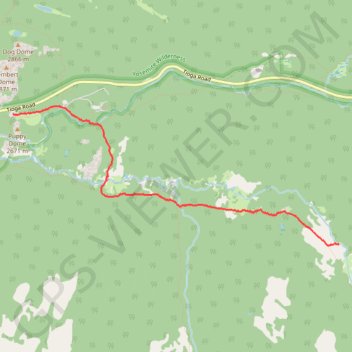
Hike back from Lyell fork of Tuolumne River along PCT
Yosemite, Tuolumne River, PCT
- Distance: 3.4 mi
- Elevation gain: 37 m
- Maximum elevation: 2,692 m
- Elevation loss: 78 m
- Minimum elevation: 2,643 m
- Moving time: 1 h 22 m
- Moving speed: 2.5 mph
- Maximum speed: 4.5 mph
- Total time: 1 h 34 m
- Global speed: 2.2 mph
Interactive trail map
Thank you for supporting this site ❤️
Make a donation
Make a donation
Gear up for your next adventure:
As an Amazon Associate, this site earns from qualifying purchases at no extra cost to you.
Trail profile
- Distance: 3.4 mi
- Elevation gain: 37 m
- Maximum elevation: 2,692 m
- Elevation loss: 78 m
- Minimum elevation: 2,643 m
- Moving time: 1 h 22 m
- Moving speed: 2.5 mph
- Maximum speed: 4.5 mph
- Total time: 1 h 34 m
- Global speed: 2.2 mph
Thank you for supporting this site ❤️
Make a donation
Make a donation
Gear up for your next adventure:
As an Amazon Associate, this site earns from qualifying purchases at no extra cost to you.
About this trail
Name: Hike back from Lyell fork of Tuolumne River along PCT trail, distance, elevation, map, profile, GPS track
Start: John Muir Trail, Tuolumne County, California, United States (37.86245 -119.30057)
Coordinates: 37.86234 -119.34599 37.87767 -119.30057
Thank you for supporting this site ❤️
Make a donation
Make a donation
Gear up for your next adventure:
As an Amazon Associate, this site earns from qualifying purchases at no extra cost to you.