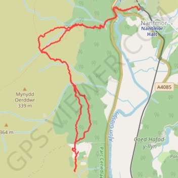
Aberglaslyn towards Cae Coch - thwarted due to too much vegetation
Gwynedd Walking
- Distance: 4.9 mi
- Elevation gain: 388 m
- Maximum elevation: 214 m
- Elevation loss: 388 m
- Minimum elevation: 19 m
- Moving time: 3 h 16 m
- Moving speed: 1.5 mph
- Maximum speed: 3.4 mph
- Total time: 4 h 18 m
- Global speed: 1.1 mph
Interactive trail map
Trail profile
- Distance: 4.9 mi
- Elevation gain: 388 m
- Maximum elevation: 214 m
- Elevation loss: 388 m
- Minimum elevation: 19 m
- Moving time: 3 h 16 m
- Moving speed: 1.5 mph
- Maximum speed: 3.4 mph
- Total time: 4 h 18 m
- Global speed: 1.1 mph
About this trail
Name: Aberglaslyn towards Cae Coch - thwarted due to too much vegetation trail, distance, elevation, map, profile, GPS track
Start: Cwm Bychan, Nantmor, Beddgelert, Gwynedd, Wales, LL55 4YG, United Kingdom (52.99478 -4.09153)
End: Cwm Bychan, Nantmor, Beddgelert, Gwynedd, Wales, LL55 4YG, United Kingdom (52.99476 -4.09145)
Coordinates: 52.97764 -4.10924 52.99519 -4.09136
Topography: Gwynedd topographic map, elevation, terrain
Other hiking, mountain biking, running and outdoor activity trails
Click on a trail to view its statistics, map and profile.
Nantgwynant, Gwynedd - Red Dragon, White Dragon
United Kingdom > Wales > Gwynedd > Beddgelert
A circular walks with wonderful views on clearly defined paths along rivers, woods and some exposed hillsides. Parts may be boggy and muddy at times with rock sections that can be slippery if wet. There are options to shorten the walk.
Distance: 10.6 mi • Elevation gain: 654 m • Maximum elevation: 325 m
Beddgelert, Llyn Dinas, Blaen Nanmor and Nantmor circuit
United Kingdom > Wales > Gwynedd > Beddgelert
Distance: 9.4 mi • Elevation gain: 393 m • Maximum elevation: 182 m
Ultra-Trail Snowdonia Eryri UTS 100M
United Kingdom > Wales > Gwynedd > Llanberis
Distance: 101.4 mi • Elevation gain: 9,704 m • Maximum elevation: 1,058 m