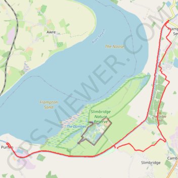
Sharpness Canal
Stroud Walking
- Distance: 12.7 mi
- Elevation gain: 41 m
- Maximum elevation: 18 m
- Elevation loss: 41 m
- Minimum elevation: 8 m
- Moving time: 4 h 13 m
- Moving speed: 3.0 mph
- Maximum speed: 5.8 mph
- Total time: 5 h 55 m
- Global speed: 2.1 mph
Interactive trail map
Trail profile
- Distance: 12.7 mi
- Elevation gain: 41 m
- Maximum elevation: 18 m
- Elevation loss: 41 m
- Minimum elevation: 8 m
- Moving time: 4 h 13 m
- Moving speed: 3.0 mph
- Maximum speed: 5.8 mph
- Total time: 5 h 55 m
- Global speed: 2.1 mph
About this trail
Name: Sharpness Canal trail, distance, elevation, map, profile, GPS track
Coordinates: 51.73253 -2.44885 51.77453 -2.36738
Topography: Gloucestershire topographic map, elevation, terrain
Other hiking, mountain biking, running and outdoor activity trails
Click on a trail to view its statistics, map and profile.
Frampton On Severn Loop Walk
United Kingdom > England > Gloucestershire > Stroud > Frampton on Severn > Church End
Distance: 4.5 mi • Elevation gain: 27 m • Maximum elevation: 21 m
Frampton on Severn loop walk
United Kingdom > England > Gloucestershire > Stroud > Frampton on Severn > Church End
Distance: 8.7 mi • Elevation gain: 49 m • Maximum elevation: 21 m
Dean2023-311
United Kingdom > England > Oxfordshire > Oxford
Distance: 192.8 mi • Elevation gain: 3,366 m • Maximum elevation: 290 m