Mount Kalugong
- Distance: 2.9 mi
- Elevation gain: 208 m
- Maximum elevation: 1,507 m
- Elevation loss: 206 m
- Minimum elevation: 1,467 m
- Moving time: 1 h 26 m
- Moving speed: 2.0 mph
- Maximum speed: 20.4 mph
- Total time: 3 h 17 m
- Global speed: 0.9 mph
Interactive trail map
Trail profile
- Distance: 2.9 mi
- Elevation gain: 208 m
- Maximum elevation: 1,507 m
- Elevation loss: 206 m
- Minimum elevation: 1,467 m
- Moving time: 1 h 26 m
- Moving speed: 2.0 mph
- Maximum speed: 20.4 mph
- Total time: 3 h 17 m
- Global speed: 0.9 mph
About this trail
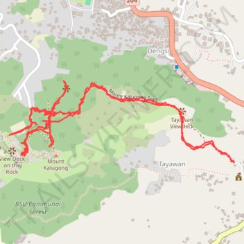
Name: Mount Kalugong trail, distance, elevation, map, profile, GPS track
Coordinates: 16.45894 120.59530 16.46201 120.60413