Make a donation
Gear up for your next adventure:
As an Amazon Associate, this site earns from qualifying purchases at no extra cost to you.
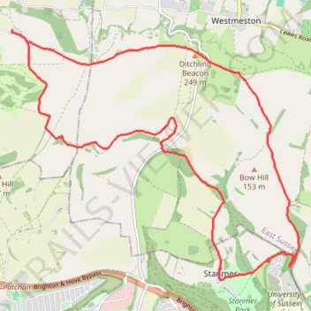
Loop walk via Jack & Jill Windmills, Ditchling Beacon and Stanmer Park
- Distance: 10.6 mi
- Elevation gain: 417 m
- Maximum elevation: 244 m
- Elevation loss: 417 m
- Minimum elevation: 78 m
- Moving time: 3 h 52 m
- Moving speed: 2.7 mph
- Maximum speed: 4.5 mph
- Total time: 4 h 45 m
- Global speed: 2.2 mph
Interactive trail map
Make a donation
Gear up for your next adventure:
As an Amazon Associate, this site earns from qualifying purchases at no extra cost to you.
Trail profile
- Distance: 10.6 mi
- Elevation gain: 417 m
- Maximum elevation: 244 m
- Elevation loss: 417 m
- Minimum elevation: 78 m
- Moving time: 3 h 52 m
- Moving speed: 2.7 mph
- Maximum speed: 4.5 mph
- Total time: 4 h 45 m
- Global speed: 2.2 mph
Make a donation
Gear up for your next adventure:
As an Amazon Associate, this site earns from qualifying purchases at no extra cost to you.
About this trail
Name: Loop walk via Jack & Jill Windmills, Ditchling Beacon and Stanmer Park trail, distance, elevation, map, profile, GPS track
Coordinates: 50.86995 -0.14861 50.90526 -0.08437
Topography: Mid Sussex topographic map, elevation, terrain
Make a donation
Gear up for your next adventure:
As an Amazon Associate, this site earns from qualifying purchases at no extra cost to you.
Other hiking, mountain biking, running and outdoor activity trails
Click on a trail to view its statistics, map and profile.
Walk - Jack and Jill Windmills, Ditchling Beacon and Stanmer Park loop
United Kingdom > England > West Sussex > Mid Sussex > Hassocks
Distance: 11.3 mi • Elevation gain: 443 m • Maximum elevation: 244 m
Walk - Jack and Jill Windmills, Street Farm, Stanmer Park
United Kingdom > England > West Sussex > Mid Sussex > Hassocks
Distance: 10.1 mi • Elevation gain: 375 m • Maximum elevation: 244 m
Stanmer circular walk
United Kingdom > England > Brighton and Hove > Stanmer
Distance: 2.3 mi • Elevation gain: 85 m • Maximum elevation: 161 m