Thank you for supporting this site ❤️
Make a donation
Make a donation
Gear up for your next adventure:
As an Amazon Associate, this site earns from qualifying purchases at no extra cost to you.
Waterworks Park loop
- Distance: 4.1 mi
- Elevation gain: 89 m
- Maximum elevation: 34 m
- Elevation loss: 89 m
- Minimum elevation: 5 m
- Moving time: 1 h 36 m
- Moving speed: 2.5 mph
- Maximum speed: 7.2 mph
- Total time: 1 h 43 m
- Global speed: 2.4 mph
Interactive trail map
Thank you for supporting this site ❤️
Make a donation
Make a donation
Gear up for your next adventure:
As an Amazon Associate, this site earns from qualifying purchases at no extra cost to you.
Trail profile
- Distance: 4.1 mi
- Elevation gain: 89 m
- Maximum elevation: 34 m
- Elevation loss: 89 m
- Minimum elevation: 5 m
- Moving time: 1 h 36 m
- Moving speed: 2.5 mph
- Maximum speed: 7.2 mph
- Total time: 1 h 43 m
- Global speed: 2.4 mph
Thank you for supporting this site ❤️
Make a donation
Make a donation
Gear up for your next adventure:
As an Amazon Associate, this site earns from qualifying purchases at no extra cost to you.
About this trail
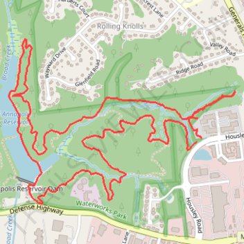
Name: Waterworks Park loop trail, distance, elevation, map, profile, GPS track
Coordinates: 38.98699 -76.56849 38.99524 -76.55396
Thank you for supporting this site ❤️
Make a donation
Make a donation
Gear up for your next adventure:
As an Amazon Associate, this site earns from qualifying purchases at no extra cost to you.