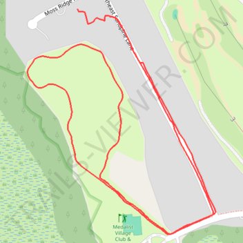
Hobe Sound medalist paths
- Distance: 1.5 mi
- Elevation gain: 8 m
- Maximum elevation: 10 m
- Elevation loss: 9 m
- Minimum elevation: 6 m
- Moving time: 41 m 35 s
- Moving speed: 2.2 mph
- Maximum speed: 3.6 mph
- Total time: 42 m 13 s
- Global speed: 2.1 mph
Interactive trail map
Trail profile
- Distance: 1.5 mi
- Elevation gain: 8 m
- Maximum elevation: 10 m
- Elevation loss: 9 m
- Minimum elevation: 6 m
- Moving time: 41 m 35 s
- Moving speed: 2.2 mph
- Maximum speed: 3.6 mph
- Total time: 42 m 13 s
- Global speed: 2.1 mph
About this trail
Name: Hobe Sound medalist paths trail, distance, elevation, map, profile, GPS track
Start: 9932, Southeast Sandpine Lane, Martin County, Florida, 33455, United States (27.08278 -80.16143)
End: 6330, Moss Ridge Point, Martin County, Florida, 33455, United States (27.08292 -80.16210)
Coordinates: 27.07872 -80.16315 27.08292 -80.15921