Thank you for supporting this site ❤️
Make a donation
Make a donation
Gear up for your next adventure:
As an Amazon Associate, this site earns from qualifying purchases at no extra cost to you.
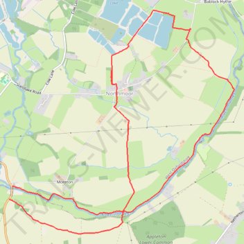
Northmoor - River Thames
- Distance: 7.8 mi
- Elevation gain: 30 m
- Maximum elevation: 69 m
- Elevation loss: 30 m
- Minimum elevation: 61 m
- Moving time: 3 h 16 m
- Moving speed: 2.4 mph
- Maximum speed: 4.6 mph
- Total time: 3 h 30 m
- Global speed: 2.2 mph
Interactive trail map
Thank you for supporting this site ❤️
Make a donation
Make a donation
Gear up for your next adventure:
As an Amazon Associate, this site earns from qualifying purchases at no extra cost to you.
Trail profile
- Distance: 7.8 mi
- Elevation gain: 30 m
- Maximum elevation: 69 m
- Elevation loss: 30 m
- Minimum elevation: 61 m
- Moving time: 3 h 16 m
- Moving speed: 2.4 mph
- Maximum speed: 4.6 mph
- Total time: 3 h 30 m
- Global speed: 2.2 mph
Thank you for supporting this site ❤️
Make a donation
Make a donation
Gear up for your next adventure:
As an Amazon Associate, this site earns from qualifying purchases at no extra cost to you.
About this trail
Name: Northmoor - River Thames trail, distance, elevation, map, profile, GPS track
Coordinates: 51.70379 -1.41771 51.73349 -1.36933
Topography: Vale of White Horse topographic map, elevation, terrain
Thank you for supporting this site ❤️
Make a donation
Make a donation
Gear up for your next adventure:
As an Amazon Associate, this site earns from qualifying purchases at no extra cost to you.
Other hiking, mountain biking, running and outdoor activity trails
Click on a trail to view its statistics, map and profile.
Dean2023-311
United Kingdom > England > Oxfordshire > Oxford
Distance: 192.8 mi • Elevation gain: 3,366 m • Maximum elevation: 290 m