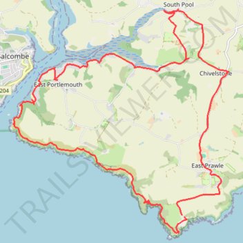
East Prawle
- Distance: 14.3 mi
- Elevation gain: 790 m
- Maximum elevation: 139 m
- Elevation loss: 780 m
- Minimum elevation: 1 m
- Moving time: 6 h 36 m
- Moving speed: 2.2 mph
- Maximum speed: 3.9 mph
- Total time: 7 h 31 m
- Global speed: 1.9 mph
Interactive trail map
Trail profile
- Distance: 14.3 mi
- Elevation gain: 790 m
- Maximum elevation: 139 m
- Elevation loss: 780 m
- Minimum elevation: 1 m
- Moving time: 6 h 36 m
- Moving speed: 2.2 mph
- Maximum speed: 3.9 mph
- Total time: 7 h 31 m
- Global speed: 1.9 mph
About this trail
Name: East Prawle trail, distance, elevation, map, profile, GPS track
Coordinates: 50.20269 -3.77252 50.24827 -3.70394
Topography: South Hams topographic map, elevation, terrain