Import a GPX file

Loop hike via Ladies Track and Castle Hill in Townsville

  • Distance: 4.1 mi
  • Elevation gain: 298 m
  • Maximum elevation: 268 m
  • Elevation loss: 276 m
  • Minimum elevation: 16 m
  • Moving time: 1 h 26 m
  • Moving speed: 2.8 mph
  • Maximum speed: 29.0 mph
  • Total time: 2 h 3 m
  • Global speed: 2.0 mph

Interactive trail map

Trail profile

  • Distance: 4.1 mi
  • Elevation gain: 298 m
  • Maximum elevation: 268 m
  • Elevation loss: 276 m
  • Minimum elevation: 16 m
  • Moving time: 1 h 26 m
  • Moving speed: 2.8 mph
  • Maximum speed: 29.0 mph
  • Total time: 2 h 3 m
  • Global speed: 2.0 mph

About this trail

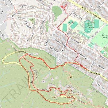
Name: Loop hike via Ladies Track and Castle Hill in Townsville trail, distance, elevation, map, profile, GPS track

Start: Roper Street, North Ward, Townsville, Townsville City, Queensland, 4810, Australia (-19.24742 146.80355)

End: 336, Stanley Street, North Ward, Townsville, Townsville City, Queensland, 4810, Australia (-19.25531 146.80680)

Coordinates: -19.25949 146.79765 -19.24702 146.80680

Gear up for your next adventure:

🎒Hiking Daypacks (20L) - Compact backpacks for day trips and technical mountain ascents
🧤Thermal Touchscreen Gloves - Stay warm while operating your GPS or smartphone camera
Insulated Travel Mugs - Keep drinks hot while surveying the landscape from a summit
🚲Bikepacking Frame Bags - Storage for tools and navigation gear on long off-road rides
🔭Compact Hiking Binoculars - Lightweight optics for scouting terrain and spotting wildlife

As an Amazon Associate, this site earns from qualifying purchases at no extra cost to you.