Thank you for supporting this site ❤️
Make a donation
Make a donation
Gear up for your next adventure:
As an Amazon Associate, this site earns from qualifying purchases at no extra cost to you.
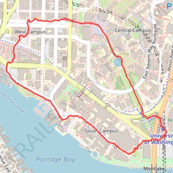
Trace around west side of University of Washington, near the hospital and lake union
- Distance: 2.1 mi
- Elevation gain: 59 m
- Maximum elevation: 54 m
- Elevation loss: 59 m
- Minimum elevation: 5 m
- Moving time: 58 m 27 s
- Moving speed: 2.1 mph
- Maximum speed: 2.4 mph
- Total time: 59 m 20 s
- Global speed: 2.1 mph
Interactive trail map
Thank you for supporting this site ❤️
Make a donation
Make a donation
Gear up for your next adventure:
As an Amazon Associate, this site earns from qualifying purchases at no extra cost to you.
Trail profile
- Distance: 2.1 mi
- Elevation gain: 59 m
- Maximum elevation: 54 m
- Elevation loss: 59 m
- Minimum elevation: 5 m
- Moving time: 58 m 27 s
- Moving speed: 2.1 mph
- Maximum speed: 2.4 mph
- Total time: 59 m 20 s
- Global speed: 2.1 mph
Thank you for supporting this site ❤️
Make a donation
Make a donation
Gear up for your next adventure:
As an Amazon Associate, this site earns from qualifying purchases at no extra cost to you.
About this trail
Name: Trace around west side of University of Washington, near the hospital and lake union trail, distance, elevation, map, profile, GPS track
Coordinates: 47.64832 -122.31765 47.65639 -122.30349
Thank you for supporting this site ❤️
Make a donation
Make a donation
Gear up for your next adventure:
As an Amazon Associate, this site earns from qualifying purchases at no extra cost to you.
Other hiking, mountain biking, running and outdoor activity trails
Click on a trail to view its statistics, map and profile.
Biking around Seattle
United States > Washington > King County > Seattle
Distance: 29.6 mi • Elevation gain: 407 m • Maximum elevation: 55 m