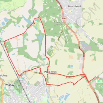
Gravel loop ride between Burntstump Country Park and Newstead Abbey Gardens
- Distance: 10.8 mi
- Elevation gain: 163 m
- Maximum elevation: 123 m
- Elevation loss: 152 m
- Minimum elevation: 64 m
- Moving time: 1 h 40 m
- Moving speed: 6.5 mph
- Maximum speed: 23.6 mph
- Total time: 2 h 45 m
- Global speed: 3.9 mph
Interactive trail map
Trail profile
- Distance: 10.8 mi
- Elevation gain: 163 m
- Maximum elevation: 123 m
- Elevation loss: 152 m
- Minimum elevation: 64 m
- Moving time: 1 h 40 m
- Moving speed: 6.5 mph
- Maximum speed: 23.6 mph
- Total time: 2 h 45 m
- Global speed: 3.9 mph
About this trail
Name: Gravel loop ride between Burntstump Country Park and Newstead Abbey Gardens trail, distance, elevation, map, profile, GPS track
Coordinates: 53.04779 -1.21835 53.08169 -1.14093
Topography: Gedling topographic map, elevation, terrain