
Gull Lakes Trail to Big Moose Lake Inlet
- Distance: 1.2 mi
- Elevation gain: 30 m
- Maximum elevation: 628 m
- Elevation loss: 76 m
- Minimum elevation: 557 m
- Moving time: 30 m 59 s
- Moving speed: 2.4 mph
- Maximum speed: 10.6 mph
- Total time: 32 m 33 s
- Global speed: 2.3 mph
Interactive trail map
Trail profile
- Distance: 1.2 mi
- Elevation gain: 30 m
- Maximum elevation: 628 m
- Elevation loss: 76 m
- Minimum elevation: 557 m
- Moving time: 30 m 59 s
- Moving speed: 2.4 mph
- Maximum speed: 10.6 mph
- Total time: 32 m 33 s
- Global speed: 2.3 mph
About this trail
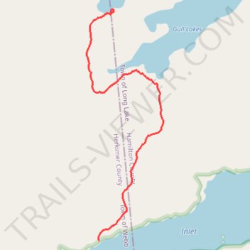
Name: Gull Lakes Trail to Big Moose Lake Inlet trail, distance, elevation, map, profile, GPS track
Start: Town of Long Lake, Hamilton County, New York, 13436, United States (43.85722 -74.82510)
End: 123, Judson Road, Town of Webb, Herkimer County, New York, 13331, United States (43.84649 -74.82589)
Coordinates: 43.84649 -74.82673 43.85743 -74.82170
Other hiking, mountain biking, running and outdoor activity trails
Click on a trail to view its statistics, map and profile.
